Almost everyone who visits California plans to drive along the iconic Highway 1. Most will choose to travel
the most famous section of this road – between the towns of Monterey and Morro Bay (South of San Francisco and North of Los Angeles). But California is a long state, and Highway 1 reaches almost all of its beaches. There are quite a few other spectacular areas along Highway 1, which may not be as famous, but are just as beautiful (maybe even more so). A road trip along these sections of Highway 1 is highly recommended and offers a chance to visit beautiful parks, drive along towering cliffs and reach picturesque towns.
There are two main areas of Highway 1 that are not part of the most famous stretch of road (the one between Monterey and Morro Bay) that are worth driving. One is north of San Francisco (top) and the other is south of it (bottom).
A map of the more famous section of the road, between Monterey and Morro Bay:
Below is a list of recommended sites along the section of Highway 1 north of San Francisco – arranged from north to south:
The length of the drive in this section (from the intersection of Highways 1 and 101 in the north to the city of San Francisco in the south) is about 6 hours net (gross length is at least 8 hours drive, without significant stops). We recommend splitting the way into three days of travel. You can also shorten the trip by cutting to the faster Highway 101 at any point – for example, switch to Highway 101 after arriving in Bodega Bay (and give up driving along Highway 1 from Bodega Bay south to San Francisco).
.
Highway 101 to Fort Bragg:
A narrow, steep drive down towering cliffs high above the ocean will take you from the intersection of Highways 1 and 101 to the town of Fort Bragg. The road passes through Redwood forests, and towards the drive’s end you can see the ocean peeking through the trees. Eventually the road reaches the edge of a massive cliff rising high above the coastline, revealing a view that is difficult to describe in words. Turquoise waters and distant islands, continue to accompany you as you make your way south to Fort Bragg, formerly a forestry center, where an active fishing port still operates (Noyo Harbor) . Due to the fact that the town’s surrounding cliffs are mostly barren (the region’s forests ere mostly cut down in the middle of the 19th century) the view is mostly panoramic. The road nearing Fort Bragg is adjacent toe the cliff edge and lacks a safety barrier (not easy for those with fear of heights). The road is prone to landslides, so before setting off you should make sure that it is indeed open and closure free. Along the way are several points where you can stop and reach the coastline, as well as some nice state parks, the most impressive of which is the
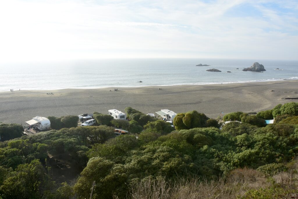
MacKerricher State Park, where a short hike will take you to a particularly beautiful observation point, on a beach decorated with rocks and small islands. The park is located at the edge of a peninsula, and apart from seals resting on the rocks, you might even spot some whales.
.
.
 A small fishing boat adjacent a whale near MacKerricher State Park
Fort Bragg to Gualala
The drive south from Fort Bragg is less impressive, but there are still some good view points along the way and quite a few state parks in the adjacent beaches and river mouths, such as
Russian Gulch State Park, where beautiful hiking trails will take you alongside the beach .A large sinkhole fed by sea water (Devil’s Punchbowl) is located in the park. About a 15 minutes’ drive south of Fort Bragg is Mendocino, a town of galleries, restaurants and cafes, which can be quite crowded with tourists. Like most towns in the area, Mendocino is also located next to a beautiful beach. Near the town lies
Mendocino Headlands State Park where there is a trail above the coastal cliffs. The drive south of Mendocino to the small community of Elk is stunning. Countless islands and coves adorn the ocean waters and the view extends onto the distance. Some nice state parks are to be found along the way, such as
Van Damme State Park (which boasts the green and lush ‘Fern Canyon’ along the Little River. A five mile hike from the campground will take you there). It is also worth stopping in the beautiful Navarro Beach. South of Elk is the small town of Point Arena, where you can go
kayaking, whale watching or fishing. Not far from Point Arena you can go on a nice
horseback tour along the beach. The beautiful and picturesque
Point Arena Lighthouse, undoubtedly worth a visit, is also not far from town (and also offers lodging accommodation). The Road south if Fort Bragg is of much better quality than its northern counterpart. The road is also farter from the coastal cliffs. which in turn are not as steep as north of Fort Bragg, leading to lesser views which are seen only sporadically. Gualala is a relatively large town located at the mouth of the Gualala River. The river marks the border of Mendocino and Sonoma Counties. The further you continue south, the warmer the weather will become, and you will see more birds, mostly Pelicans and Turkey Vultures.
.
A guesthouse in Mendocino Navarro Beach
Point Arena Lighthouse
Gualala to Bodega Bay
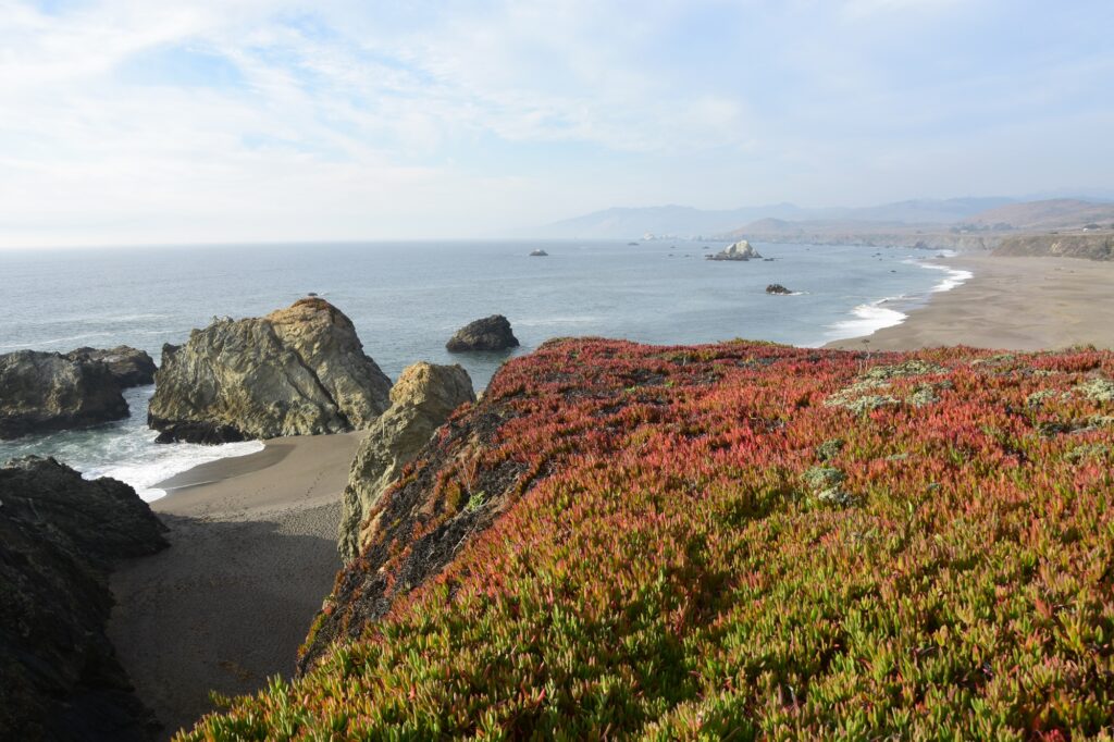
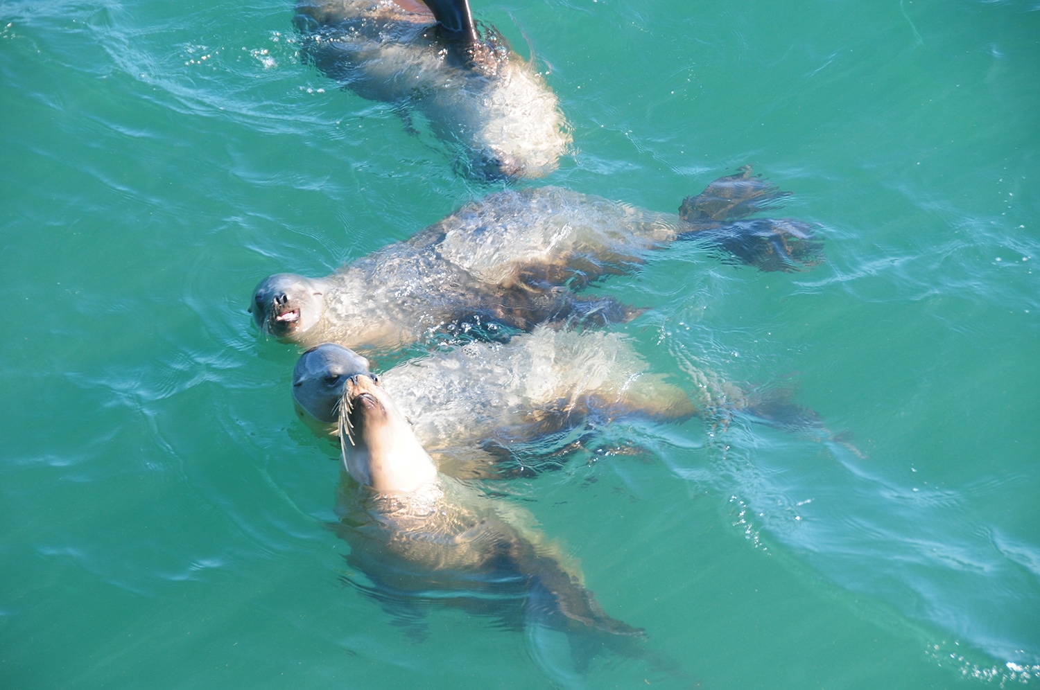
Making your way south from Gualala, you should visit Salt Point State Park where the beautiful Salt Point Trail will take you along the costal cliffs, offering a chance to see the many seals on the small islands along the way. The next destination southwards is the town of Jenner, on the banks of the Russian River. The drive between Salt Point and Jenner is without doubt the icing in the cake of Highway 1 – a reminder when it comes to costal views, California is the real thing. Before driving down to Jenner (the road winds down from the mighty cliffs to the town located at sea level) you should hike to Vista Point, a short walk with spectacular views (starts 4 miles north of Jenner). Several great state parks are located around Jenner, namely reserves Sonoma Coast State Park, in it which are great sites such as: Goat Rock State Beach, from where you can go to the mouth of the Russian River and see seal (you can even swim near them), Wrights Beach (another great beach) and Duncan’s Landing (a side road that leads to an amazing view). The park also has great campgrounds. Jenner is also a perfect place to go kayaking in the mouth of the Russian River (calm and suitable for the whole family). From here Bodega Bay and the end of this section of Highway 1 is near. In Bodega Bay you can enjoy a delicious Clam Chowder (Spud Point Crab Company) before continuing south.
For recommended hotels in Jenner click here
 Seals in Salt Point State Park
 Ocean views near Jenner
 A beautiful campground near Wrights Beach
 Duncan’s Landing
Bodega Bay to San Francisco
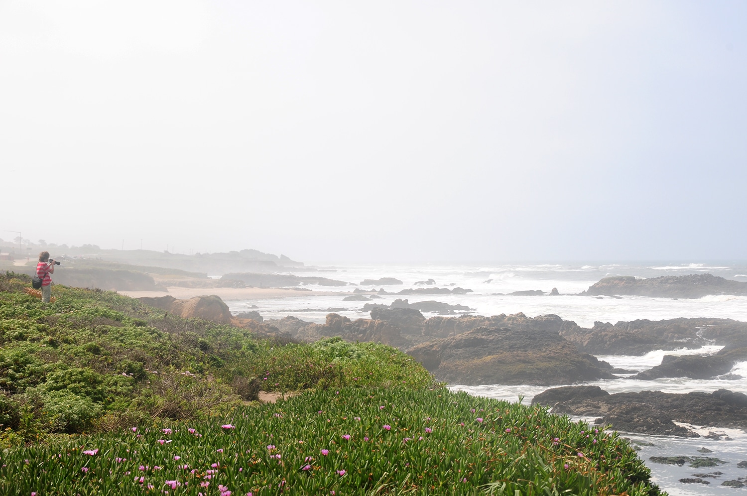
The southbound drive from Bodega Bay to San Francisco is less scenic than the northern parts of the road, but still features some gems (this part of the road can also make a great day trip outside of San Francisco). The first destination you will arrive is Tomales Bay, a perfect place for kayaking (with excellent chances of seeing seals). Further on, a slight deviation from Highway 1, on a side road leading west to the Point Reyes Lighthouse lives an elephant seal colony. The lighthouse is located in the Point Reyes National Seashore, and sits at the edge of a peninsula. The road to the lighthouse passes by agricultural farms, horse and cattle herds and round hills bare of vegetation (due to the strong winds in the area). Just before the lighthouse – at the end of the road leading to Chimney Rock, lives the colony. The road ends half a mile before the lighthouse and to reach it you have to continue by foot. From the lookout at the top of the lighthouse you can see the stormy ocean waters, and with a little luck and patience you can spot gray whales (in winter and spring), dolphin schools and lots of sea lions. Further south is the community of Stinson Beach, with a beautiful sandy beach (adorned with warning signs about the sharks that frequent this area, which is also abundant with marine mammals). For those who know how to surf and are not afraid of sharks – this is the perfect place rent a surfboard. Just before leaving Highway 1 for Highway 101 to San Francisco, you can go up to the Mount Tamalpais State Park for a great view from the area (see location here). If you still have time and energy left, you can also visit the Muir Woods National Monument and see giant Redwood trees- the tallest trees in the world (note that parking must be reserved in advance). When entering San Francisco through the Golden Gate Bridge, be sure to stop at the bridge’s northwest observation point (just before getting on the bridge, see location here), from which the Golden Gate Bridge and the city of San Francisco can be seen in all their beauty.
For recommended hotels in San Francisco click here.
Below is a list of recommended sites along the section of south of San Francisco – arranged from north to south:
The length of this section (from San Francisco to Monterey) is about 3 hours net drive (at least 4 hours drive gross, without significant stops) and you can spend a full day’s trip driving it. This section of the road is less impressive in terms of scenery than the other two sections (the one north of San Francisco and the one south of Monterey) but there are many unique points of interest along the way, making it undoubtedly worth a visit.
.
The first recommended stop along the way is the community of Moss Beach, near which is the
Fitzgerald Marine Reserve. The reserve is rich in birdlife and tidepools, which are inhabited by marine invertebrates and many seals and sea lions. A little south of the Fitzgerald Marine Reserve lies the town of Half Moon Bay, famous for its beaches’ massive waves, which attract surfers from all over the world. You can stop here early lunch (or late breakfast) at one of the waterfront restaurants near the town’s marina.
.
South of Half Moon Bay lies
Ano Nuevo State Park. One of the largest elephant seal colonies in the world, every winter thousands of pregnant females arrive at the park to give birth. Shortly afterwards arrive the bulls, and their courtship battles are the peak of the activity that swarms the beach every winter. In March, the males begin to leave the beach. The females leave immediately afterwards, leaving behind their offspring who will have to survive on their own. During this period (April-May) you can hear their heart-wrenching wails, as they search for their missing mother. In less than two months, the pups learn to swim and find food on their own, and soon they too turn to the open sea and migrate north along the coasts of Washington State and Vancouver Island. Visiting the park requires walking three miles. The park is closed on December 1-14, and from December to the end of March it can only be visited by guided groups. Reservations must be made in advance. During the rest of the year, you can visit the park independently. During this period, you can see elephant seals which come to the beach to shed their skin. At this stage of their lives, elephant seals usually lie motionless on the sand, and watching them is less interesting.
.
Further south be sure to visit the city of Santa Cruz where you should go to the famous boardwalk. I recommend starting your visit at the city wharf, which extends for about a half a mile into the ocean (this is a perfect place to watch whales – all seasons of the year. Keep your eyes open and search patiently). The wharf is constantly inhabited by amateur fishermen trying to bring in a catch, and down in the water kayaks sail among the sea lions. Many sea lions are concentrated on the pier’s pillars, and can be seen and heard while walking along it (especially at its end). Many surfers gather south of the wharf, and if you know and like to surf, this is an excellent place to consider doing it. If the weather is not too cold you can even go for a swim. You should also visit the amusement park near the beach where there is a large selection of rides (entry is free, you pay only to take the rides. The park is not open every day, except during summer.
Click here for updated opening hours). See location of the park
here.
.
South of Santa Cruz, if time permits, you can visit the town of Capitola, which lies on the shore of a small bay (with a particularly nice bathing beach). The town has colorful and picturesque houses, restaurants and art galleries. Another site near Highway 1 in this section of the trip is ‘
The Mystery Spot‘, a tourist complex where seemingly the laws of physics have gone mad – balls rolling upwards, chairs standing on walls, a curved floor that is actually straight as a level, and more (a nice stop for those with children but commercialized and definitely not mandatory). Just before you end your trip on this section of Highway 1, you can use the rest of the day to go kayaking in the Elkhorn Slough. Opposite this channel of brackish water, which is more than six miles long, is the mouth of the submarine Monterey Canyon. It was once assumed that the canyon was formed due to an ancient river being submerged. However, today scientists believe that the formation of the canyon is related to geological fractures and the continental drift. Either way, the steep slope near the beach leads to many marine animals that usually live in the open sea to get close to shore. Thanks to this, the Elkhorn Slough channel is rich in eagle and sting rays, seals, sea lions, otters, tiger sharks, and more than 200 species of birds. The channel is a perfect place to go kayaking (you can
rent one here). From here it’s a short drive to the town of Monterey – where the more famous section of Highway 1, that which winds along the coasts of central California, begins.
.
For recommended hotels in Monterey click here.
 A typical view from Highway 1 south of San Francisco
 An elephant seal near Highway 1
 The beach and amusement park in Santa Cruz
 The Santa Cruz coast
 The famous wharf in Santa Cruz
 Playful sea lions near the Santa Cruz Wharf
We recommend driving Highway 1 south-bound, as then you drive on the road’s oceanside and its easier to stop at the lookout points. That said, the difference is not that big and driving north is also a great experience.
Note that Highway 1 frequently closes due to landslides. Be sure to check that the road is open before embarking on your trip. You can check for current traffic restrictions here.
Click here for more travel destinations in California.
Click here for more information of Highway 1 south of Monterey.
 A small fishing boat adjacent a whale near MacKerricher State Park
 Navarro Beach
 Seals in Salt Point State Park
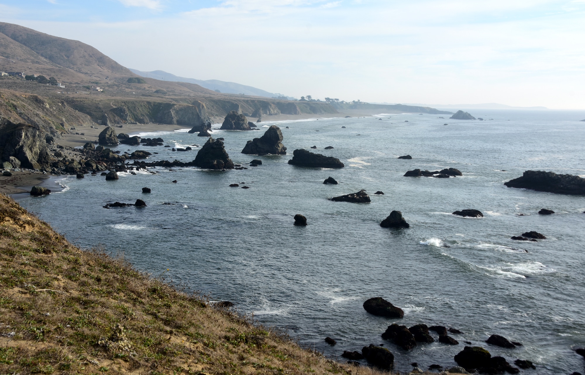 Ocean views near Jenner
 A beautiful campground near Wrights Beach
 Duncan’s Landing