Sequoia National Park and Kings Canyon National Park lie side by side in the southern Sierra Nevada mountains, east of the San Joaquin Valley, which crosses the state of California along its length. Sequoia National Park is the second national park to be declared in the United States, after Yellowstone. The park was founded on September 25, 1890, only six days before Yosemite National Park (which was the third park to be declared). Fifty years later Kings Canyon was designated a National Park, and today, the two parks act as one geographical area.
Americans like to rank everything: the longest bridge, the highest mountain, the biggest dam, etc. The residents of California have many things to be proud of in Sequoia and Kings Canyon National Parks: within the boundaries of Sequoia National Park grows General Sherman, which at a height of 250 feet and a ground circumference of 103 feet is the largest tree in the world (by volume). If that’s not enough, the highest point in the Contiguous United States, Mount Whitney (14,505) also resides in Sequoia National Park. The Kings River Canyon, in the heart of Kings Canyon National Park, is considered the deepest canyon in the United States, the river lies at a depth of 8,200 feet bellow its surrounding mountains. For comparison: the depth of the Grand Canyon is about 4,900 feet and the depth of Hells Canyon in the state of Idaho is about 7,900 feet (although the basis of the comparison is somewhat imprecise, since Kings Canyon was formed by glacier grinding, while Hells Canyon and the Grand Canyon were formed by the water erosion).
Sequoia & Kings Canyon National Parks are located in a much less visited and developed area than that of Yosemite National Park to the north. This area is a paradise for nature and hiking lovers (and also a perfect place for camping, especially for those staying in a tent, in the variety of campgrounds throughout the park). Most of the region is remote and accessible only by long foot journeys. One of the things that makes Sequoia & Kings Canyon National Parks so unique is the extraordinary range of heights in their territories – from an altitude of just 1,200 ft to an altitude of over 14,000 ft above sea level. Therefore, the reserves have a great variety of habitats and a great abundance of plant and animal life. The parks’ main areas include the Foothills, which are characterized by gentle hills and flowing rivers between them in the southwest of Sequoia National Park; The Mineral King area, in the south of Sequoia National Park, an isolated and alpine region, which in its territory is lies Mount Whitney; The ‘Giant Forest’ area in the center of Sequoia National Park, where the largest tree in the world, General Sherman, grows. Moro Rock, a block of granite whose summit offers a great view of the Sierra Nevada mountains, also lies in this region; The Grant Grove area, which includes the sequoia forests in the western part of Kings Canyon National Park, home to General Grant, the second largest in the world; Cedar Grove area, in the eastern part of the King Canyon Park, which includes an impressive valley where the Kings River flows. This valley was carved by glaciers at the end of the last ice age (and therefore its ‘U’ shape, compared to canyons formed by the flow of rivers, which are usually ‘sharper’ and ‘V’ shaped). In addition to all these, the entire region is networked with an underground system of karst caves, which make the world under the parks’ soil particularly interesting.
When should I visit Sequoia & Kings Canyons National Parks?
While possible to visit the parks year-round, some of the roads are closed during the winter months. It should be noted that the differences in altitude between the parks’ different regions are significant, and create a great variation in temperature and precipitation. Below is a breakdown of the weather in the parks during the different seasons:
Spring (March-May): Springtime sees a gradual warming, starting at the lower elevated Foothills, and continuing to the parks’ higher elevations. In early spring the Foothills region is covered in a magnificent bloom of wildflowers, but in May the area starts to heat and dry up. Higher areas of the reserve are still mostly covered in snow during these months. In spring the parks’ rivers are full and their flow is strong. The road leading to Cedar Grove Village (Kings Canyon Scenic Byway, State Route 180) opens during April, the road leading to Moro Rock and Crescent Meadow (Crescent Meadow Rd) opens during April or May, the road in Mineral King Valley (Mineral King Rd) opens at late May, and Crystal Cave opens during May as well. Early spring is still too cold to camp in the parks. Late spring sees pleasant weather fo camping in the lower areas, but it is still cold in the higher regions.
Summer (June-August): The most popular season to visit the parks. The snow has already melted, the hiking trails are passable, the roads are open, and a large variety of activities, operated by park guides, are offered to visitors. The Foothills are very hot and dry during summer, making bathing in the rivers particularly enjoyable. Temperatures in the higher elevations are cool and pleasant. Summer temperatures are comfortable for camping. The high areas are sometimes prone to afternoon lightning storms, during which it is not advisable to climb high, barren peaks (such as Moro Rock).
Autumn (September-November): Autumn temperatures in the park gradually decline but are still comfortable for travelling and hiking in the park. From the end of October there are chances of snow in the parks’ higher elevations. Autumn sees a wonderful leaf fall and fewer tourists visit the area. Crystal Cave closes to visitors in November, and the roads to Cedar Grove Village and Mineral King close in October. Night temperatures are still comfortable for camping (about 43°F in the lower areas and about 22°F in the higher areas).
Winter (December-February): In winter, the sequoia forests are covered with snow, and walking through them is an extraordinary experience (when the snowpack is not too high, and when there is no ice on the trail). You can also go snowshoeing and cross-country skiing. Winter is a perfect season for hiking in the park’s lower regions, which remain green year-round (wildflowers start blooming as early as January in some areas of the Foothills). The roads leading to Cedar Grove Village (Route 180) and Mineral King are closed, and other roads in the reserve, including Generals Highway Hwy, are closed at times due to snow that has yet to be cleared. Daytime temperatures are comfortable in the lower areas of the parks and cold in the higher ones. Nights are usually too cold to camp, and most campgrounds are closed anyway.
Location and arrival directions:
Sequoia & Kings Canyons National Parks have two entrances: in the parks’ northwest- Big Stump Entrance, adjacent to Route 180 (this is the entrance adjacent to Grant Grove Village in Kings Canyon National Park), and in the parks’ south – Ash Mountain Entrance, adjacent to Route 198 (this is the entrance in the south of Sequoia National Park). The two roads are connected within the parks by the Generals Highway, which connects Kings Canyon in the north to Sequoia in the south. The highway is narrow and winding (mainly in its southern part) and the drive is slow. The highway is limited to vehicles up to 24 feet in length in the section between the Ash Mountain entrance and the Potwisha Campground, and up to 22 feet in the section between the Potwisha Campground and the Giant Forest area in the center of Sequoia National Park .
See the parks’ entrances (blue) and the parts where RVs are not allowed (yellow):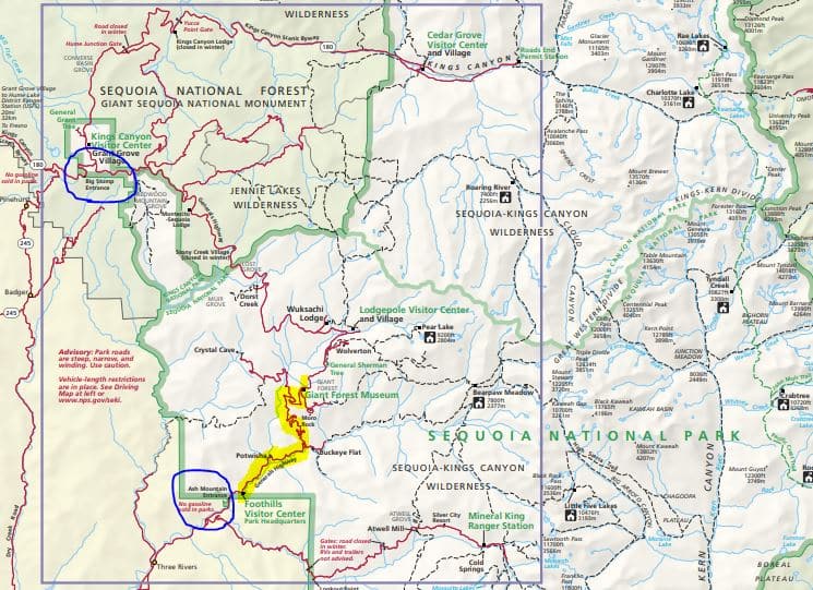
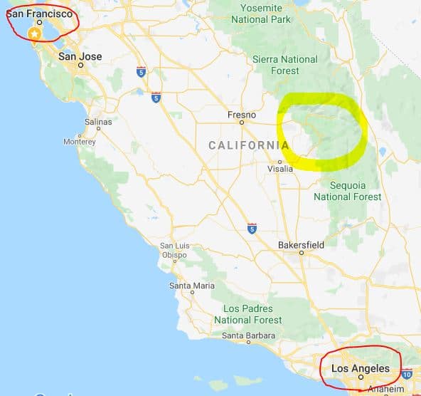
You can reach the parks from the southwest, for example from Los Angeles (4-5 hours drive), or from the northwest, for example from San Francisco (4-5 hours drive). There are no entrances to the parks from the east (due to the steep topography in the east). Many visitors combine the two parks with a visit to Yosemite National Park. The drive from the town of Oakhurst in the south of Yosemite National Park to the northwest entrance of Kings Canyon National Park takes about two hours.
See location of Sequoia and Kings Canyon National Parks (yellow) in reference to San Francisco and Los Angles.
Where to go and for how long? The parks’ different sectors:
If visiting in the summer (when the roads are open), you should spend at least two days in the parks. The first day should be dedicated to driving through Sequoia National Park from Ash Mountain entrance north along the Generals Hwy to Grant Grove Village in Kings Canyon National Park (we recommend spending the night at the John Muir Lodge).
On this day, you can combine hiking to Moro Rock and to General Sherman its surrounding sequoia forest. You can also visit the ‘Huge Forest’ museum (next to the museum, in front of the big Sentinel Tree, there are guides with information about the sequoia trees) and the Crystal Cave. It is also possible to combine a trip to the fallen sequoia tree Tunnel Log (please note, the southern part of Generals Highway, in the section south of General Sherman, is very curved and the drive is extremely slow – less than 18 m/h in some places. The road not suitable for long RVs). If you don’t want to drive this section of the road, you can enter the park from Route 180 (Big Stump entrance) and drive south to Moro Rock, General Sherman, etc.
You can dedicate the first part of the second day to the western part of Kings Canyon National Park and include a short hike to General Grant tree and to Panoramic Point. On the second part of the day you can drive to the eastern part of Kings Canyon National Park (via Route 180) and hike the nice Zumwalt Meadow Trail.
If you’re interested in longer hikes in the parks (of which there are plenty in the area) or if you plan to spend the night in one of the parks’ campgrounds (some of which are particularly beautiful, but note that some of the roads are not accessible to RVs, so it is much more convenient to spend the night in a tent rather than a caravan) , it is worth extending your visit by a couple of days.
If visiting in winter, take into account that some of the roads will be closed. In this case a one-day visit, focused mainly on the forests surrounding the trees General Sherman and General Grant, might be sufficient.
Road opening schedule and shuttles:
Generals Highway – the main road connecting the parks, is open year-round, except during and after snowstorms. Parts of the road are very winding, for example the section between the southern entrance to Sequoia National Park and the Giant Forest area has 130 bends; Driving the section between Potwisha Campground and the Giant Forest museum is not recommended for vehicles over 22 feet long (although it is possible); Driving from the Foothills Visitor Center to Potwisha Campground is not recommended for vehicles over 24 feet in length; Route 180 from Grant Grove to Cedar Grove Village (Kings Canyon Scenic Byway) usually opens during April and closes in October; Mineral King Rd is open from the end of May to the end of October and is not passable to RVs longer than 22 feet; The road leading to Crystal Cave Rd is open from early May to late November, depending on the weather, and entry for vehicles longer than 22 feet is prohibited (if traveling in an RV the parks’ shuttle service can be used); The road to Moro Rock (Crescent Meadow Rd) opens in April or May (depending on the weather) and closes during November. Crescent Meadow Rd is closed for private vehicles on weekends and national holidays from the end of May to the end of September, during the park’s shuttle service’s operating hours (usually from 9 :00 am until the afternoon). During these months the aforementioned road is closed for vehicles longer than 22 feet.
The speed limit in the curvy southern part of route 198 is 18 mph. In addition, the road closes in the winter in cases of extreme weather. It is faster to enter the parks through the western entrance of Route 180 (Big Stump entrance), and drive south form there to the Giant Forest, General Sherman Tree, Crystal Cave, etc., or east to the heart of the Kings Canyon National Park. Note that from autumn (around October) to spring (around April, during which blizzards may still occur) you might be required to carry snow chains ( in the trunk of the vehicle) on all park roads, depending on the weather.
A shuttle system operate throughout the parks (free of charge), with several routes serving the different areas of the parks. Shuttle lines in Kings Canyon: Big Tree Shuttle, operates a circular route during the summer in the Grant Grove area and stops at several stations. Shuttle lines in Sequoia: Several routes operates during the summer. The routes lines that differ in their service areas and are marked by different colors: the Giant Forest route (green), the Lodgepole line (purple), the General Sherman line (orange), the Museum line (red).
Click here for up do date information.
Lodging and camping in Sequoia & Kings Canyon:
There are four hotels in the parks’ grounds and three in their close proximity. You can also lodge in the nearby town of Three Rivers. There is a great variety of campgrounds in the parks. Most campgrounds operate on a first come-first serve basis, and during the summer they usually fill up early on weekends. To guarantee yourself a vacant site it is best to arrive at checkout time which is noon.
For a list of recommended hotels and campgrounds in the park click here.
For a map of Sequoia and Kings Canyon National Parks click here.
For other destinations in California click here.
For all 50 national parks in the lower 48 ranked by beauty click here.
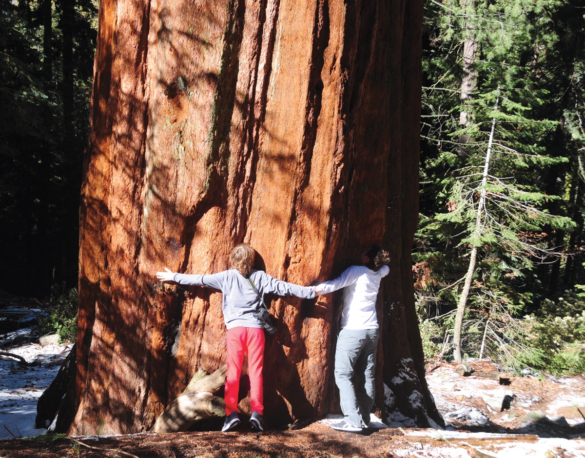
Hugging trees in Sequoia & Kings Canyon National Parks
 Sequoia trees in Sequoia National Park
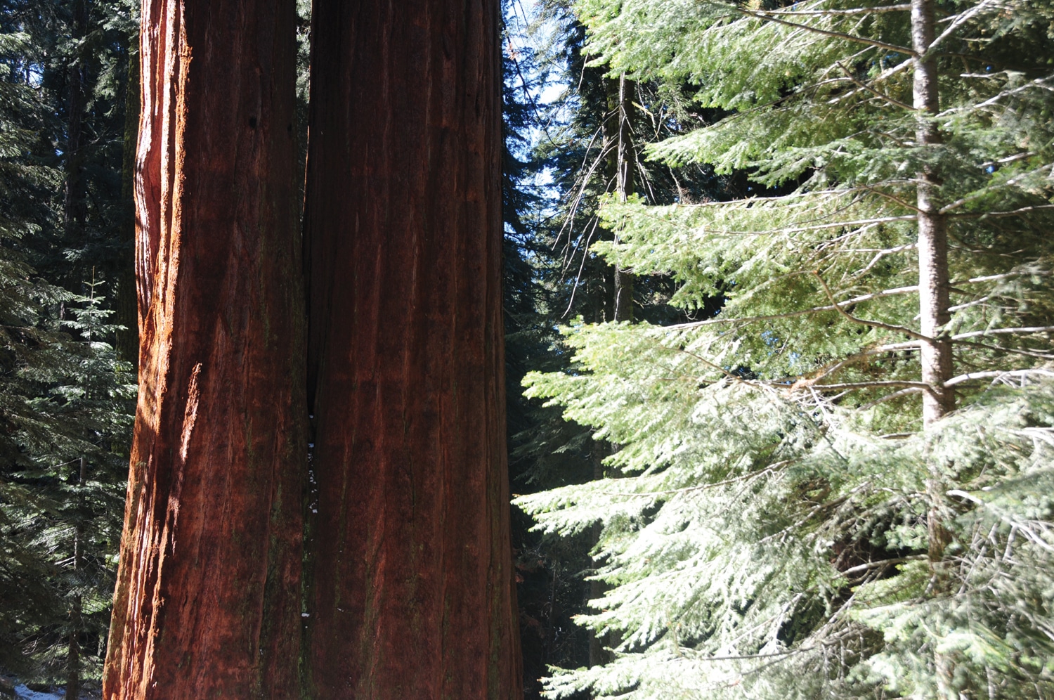
 Sequoia trees in winter
 Bathing in Kings Canyon