With an open landscape consisting of grass prairies, riverbeds and tall clay crags, Theodore Roosevelt National Park is a beautiful natural landscape in the heart of the American Great Plains, in the northern part of the Midwestern United States. The park is named after Theodore Roosevelt – the 26th president of the United States. Being both emotionally and economically attached to them, Roosevelt made the Dakotas his part time home for several years. He first arrived region in 1883, and due to his interest in the cattle industry became a partner in a local ranch before setting up his own Elkhorn Ranch which today resides in the park’s territory. While an avid hunter, Roosevelt was distressed by the white man’s destruction of the Midwest’s bison herds and open prairies. Hence, when elected president in 1901 Roosevelt established the National Forest Service, declared 18 new national monuments, and advocated for the establishment of 5 new national parks and 51 wildlife refugees across the USA. Roosevelt is yet to be the greenest, most environment-oriented president of the United States till this day, and so it seems but fitting that the only national park called after a person- be named after him.
The park’s soil is a product of layers and layers of sediment carried from the Rocky Mountains by rivers and streams. The park’s buttes and crags resemble those of the Badlands National Park, but the landscape here is more mountainous and greener, with more flowing rivers. The region changes drastically between the dry season (autumn), when the prairies are colored brown, and the wet season (late spring-early summer) when a thick greenery takes over. In between, during the cold season (late autumn till mid-spring) a layer of ice and snow covers the vast plains.
Theodore Roosevelt National Park is wonderful travel destination. The views might be less dramatic than those of its neighbours to the west, but the park holds a unique charm, especially for those devout travellers who have already seen the rest, and in several places the park offers views one might not have known exist on the planet. Endless grasslan7ds, crags and cliffs forming maze like complexes, vast open plains, and lack of people give the feeling you are truly in the middle of nowhere. These, along with an abundance of wildlife (while no bears, there is much from everything else – coyotes, bison, badgers, elks, bighorn sheep, American antelopes and even wild horses) provide for an extraordinary setting.
Location of Theodore Roosevelt NP:
When to visit Theodore Roosevelt National Park:
Summers in the park are pleasant and warm, with average high temperatures at around 80°F. Winters are cold, with temperatures way bellow freezing. Strong winds blow year-round. The Park receives little precipitation, with most falling in May-July (June is peak wet season). During these months violent thunderstorms are possible. The only months with certainly no snow (apart from extreme and infrequent events) are May-September. During these months the park’s roads are most likely to be open. Thus May-September is the recommended time to visit Theodore Roosevelt National Park.
Location and arrival directions:
Bismarck, the state capital is a two-hour drive away and has a regional airport. The Town of Dickinson is an hour’s drive away and has a tiny semi-functioning regional airport. Rapid City, South Dakota also has a regional airport and is a 4 hour drive away. If in need of an international airport, or if planning your visit as part of a larger trip, Minneapolis, Denver, Milwaukee, and Chicago are 8, 9, 13, and 14 hours away, respectively.
Theodore Roosevelt National Park – Where to visit and for how long:
Theodore Roosevelt National Park has three main sectors (of which the southern one is with no doubt more recommended), as well as a small sector with Roosevelt’s ranch (which is passable). It is best to give the north and south sectors half a day to a full day each. Both offer nice scenic drives with good chances to see wildlife, as well as several lookouts and short hiking trails. The driving time between these two sectors is 1.5-2 hours. While driving between them you can see many oil and fracking wells, which are very common in North Dakota, some towns such as Watford City have tripled their population size overnight during the ‘North Dakota Oil Boom’. Be advised as the northern unit of the park uses Central Time while the southern unit uses Mountain Time.
A map of the park’s different units:

A map of North Unit and South Unit: Road Opening schedule:
Both the North Unit’s and the South Unit’s main loop roads are closed when snowy, usually from November to March. Both roads are traversable for RVs of all lengths.
Recommended activities in Theodore Roosevelt National Park:
South Unit: Take the scenic loop road and hike along it’s adjacent trails. The drive is 36 miles long and takes more than an hour without stops. Along the road, which climbs high over the park, you can see Bison herds as well as large Prairie Dog colonies. Worthwhile stops along the road are:
1. Jones Creek trail: A short walk that leads to a small canyon surrounded by buttes and interesting flora.
2. Bullcort and Buck Hill overlooks: A wonderful view of the park’s vast open landscape, with butte fields surrounded by grass prairies.
 3. Badlands Overlook: Another nice view of the park’s badlands.
4. Ridgeline Nature Trail: A nice Trail that sums up the different topographic formations in the park. You can download a trail guide here.

A map of the park’s southern unit:
North Unit: The park’s northern unit sees less visitor traffic and is more desolate than its southern counterpart. (Though as said the scenery here is a bit less impressive than that of the southern unit). In addition to the park’s common wildlife, un the northern unit you have more chances of spotting Mountain Lions, Wolves and Moose. The unit’s 14 mile long (each way) scenic road runs close to the Little Missouri River and offers several lookouts and trail heads. Due to strong winds in the area, few trees grow along the road, as those give way to mostly Sagebrush and grass. Worthwhile stops along the way:
1. River Bend Overlook: A great observation point overlooking the Little Missouri River. A very short trail leads to the lookout. The surrounding stones are yellow in color, resembling Yellowstone NP to the west.
2. Oxbow Overlook: Another nice observation point overlooking the Little Missouri and its surrounding grass prairies. If time is limited it is possible to make do with just the previous overlook.
For those wishing to flex their bones, there are two short trail in the park’s northern unit- Little Mo Trail (easy) leading to the banks of the LIttle Missouri, and Caprock Coulee Nature Trail (medium difficulty), a round and back trail leading to colorfull stone buttes. See the trail guide booklet here. For those travelling in two cars (or if only part of the group want to take the trail), it is possible to walk Caprock Coulee trail, marked here in blue and join the trail marked in green (it is recommended to start at the blue trail’s head, thus most of the hike will be downhill). The length of this variation is 4.3 miles.


Map of the park’s North Unit with the aforementioned points marked: Lodging and Camping:
Visitors of Teddy Roosevelt National Park can stay at hotels in nearby Medora , a tiny cordial town which in some areas is themed as an old wild west outpost. If staying at Medora, inquire about town events such as rodeo shows and the annual Hot Air Balloon Rally. As far as camping the park has two gorgeous campgrounds – Cottonwood Campground in the south and Juniper Campground in the north. While both are very beautiful, Juniper campground is more isolated and scenic, especially the sites close to the river banks. However, it is not possible to reserve sites in Juniper Campground, unlike Cottonwood Campground, where some sites are reservable in advance.
For a map of Theodore Roosevelt National Park click here.
For other great destinations in the Central USA click here.
For a list of all 50 National Parks in the lower 48 click here.
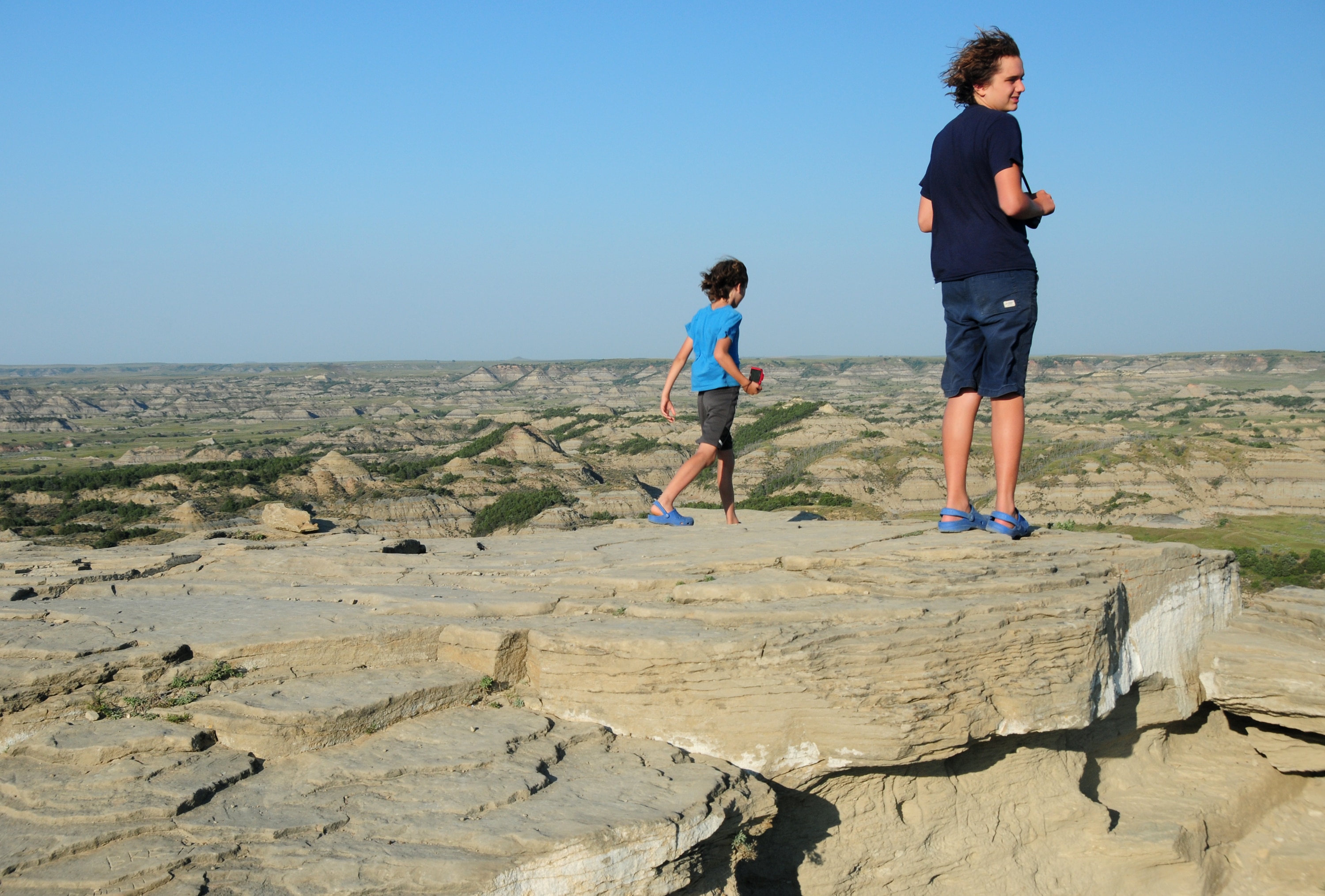 An amazing view of great butte clusters amid endless plains from Buck Hill in the southern unit of the park
 Our tent on the banks of the Little Missouri River in Cottonwood Campground
 We imagined a pastoral horse gallop through grass prairies like cowboys. Instead, we got a very strict ride in a file with other tourists. Not recommended at all
 And then the Bison showed up in front of us. Here they are the real landlords and that includes the roads as well
 Clay buttes and grass fields alongside Jones Creek Trail
 An overlook of the Little Missouri River in the park’s North Unit