Please note – in 2024 (every day during summer months and only on weekends and national holidays during transition seasons) entry to the park will be by advance reservation only. The reservation window opens on Jan 5th and you should book the second it opens, for more information scroll to the relevant message here.
In March 1851 the white man discovered one of the most stunning locations in North America. Mariposa Battalion, tasked with fighting Native American tribes in eastern California, encountered on their march a hidden valley surrounded by massive granite cliffs – Yosemite Valley. Not many years have passed and the valley saw a road paved, lodges built, and the area becoming a tourist hotspot. Due to the region’s rapid development, in 1864 President Abraham Lincoln declared the area a nature preserve – the first of its kind in the world, in an unprecedented step at that time. 26 years later the area became Yosemite National Park with the Yosemite Valley at its center.
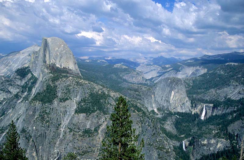 Half-Dome Peak, Vernal Falls, and Nevada Falls as seen form Glacier Peak
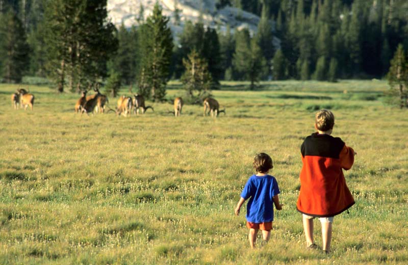
Yosemite valley, today the heart of Yosemite National Park, is surrounded by towering cliffs carved by glaciers which covered the mountain peaks tens of thousands of years ago. The Merced River traverses the valley, flowing under El Capitan and Half-Dome peaks, which rise 3,300 and 5,000 ft high above their surrounding. Steep waterfalls descend the stone cliffs, including Yosemite Falls, which at 2,425 ft make the highest waterfall in North America and the sixth highest in the world, 13 times the height of Niagara Falls. The park’s areas north and south of the valley also include some breathtaking, less visited regions.
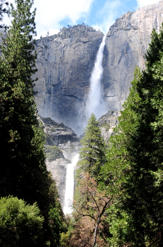 Yosemite Falls, 13 times the height of Niagara Falls
Other recommended areas in the park:
South Yosemite – The southern part of the park has two main travel sites. The Mariposa Grove of Giant Sequoias (there grows the gargantuan Grizzly Giant- reaching 209 feet of height, a circumference of 97 feet, and 2,700 years of age) and Glacier Point, to which leads a spiralling road (Glacier Point is by no doubt the most awe-striking viewpoint in the park).
North Yosemite – The regions north of the valley, alongside Tioga Pass Road (highway 120), there lie Tuolumne Meadows where the tributaries of the Tuolumne River gently wind between alpine summits and small lakes. There are great view points of the Yosemite Valley and of Half-Dome Peak alongside the road, which passes from the forested western side of the mountain range to the arid eastern side (Olmsted Point is especially recommended). The road leads to the deserts east of the Sierra Nevada Mountains through Tioga Pass (9,945 ft above sea level).
West Yosemite – Along highway 120, west of Yosemite Valley there is another valley named Hetch Hetchy. Hetch Hetchy was dammed in the 30’s and is now flooded with the water of the Tuolumne River and is a major source of drinking water for the San Francisco Bay area. The damming of the valley was followed by an environmental struggle of several organizations. For those who want to drive to an overlook above the reservoir, turn north from highway 120 near the park’s western entrance. While a nice view, those with limited time can whole heartedly pass this lookout, as the drive is long and not necessarily worth it.
 On the road from Yosemite Valley to Tuolumne Meadows (lake Tenaya is visible)
 Tuolumne Meadows
Yosemite’s Beauty and proximity to urban areas have made it a very popular tourist destination, and the crowdedness can cloud the enjoyment of visiting the park. As such, you should carefully plan your visit: book your campsites or hotel rooms in advance; refrain from visiting during weekends and national holidays; embark on long hiking trails (as most visitors hike the park’s short trails. If you plan on hiking a short trail, its best to do it in the early morning); visit the less popular areas of the park (such as Tioga Pass). Follow all these, and you will undoubtedly finish your visit with the feeling that Yosemite, although the crowds is one of the most beautiful natural wonders of the world.
For hotel recommendations near Yosemite Valley click here.
Location of Yosemite National Park:
Location of Yosemite National Park with respect to San Francisco, Las Vegas, Los Angles: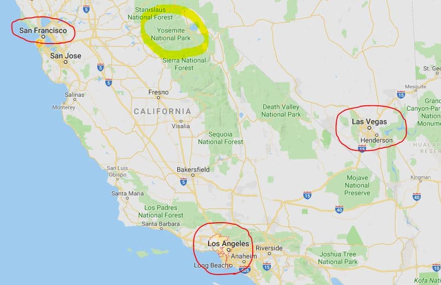
When to visit Yosemite National Park:
You can visit the park year-round, yet many roads are closed during winter (mainly the road to Mariposa Grove, the road to Glacier Point, and Tioga Pass). The exact closure dates differ every year. Temperatures in Yosemite can change drastically and greatly differ between different altitudes in the park, so it is recommended to bring warm clothes and dress accordingly.
Weather by seasons:
Spring (March-May): Springtime is a great season to visit the Yosemite Valley. The waterfalls are full of water, and the weather is usually good for hiking, although there are still chances of snowfall, especially in the beginning of the season (which might lead to road closures). The average temperature during the day is comfortable yet to cold to enjoy swimming in the park’s lakes and rivers. Night-time temperatures are cold. The valley’s beltway and the main roads leading to it (highways 120 from the west, 140 from the southwest, and 41 from the south) are open during this season (except during snowstorms), yet some of the park’s other roads are still closed due to snow from the winter. Some of the hiking trails which climb to higher elevations are still closed during early spring but open near its end. Early spring might still be too cold to camp in the park but towards the end of the season the weather becomes suitable for camping.
 Vernal Falls – water flow is at its peak during springtime
Summer (June-August): The most crowded season in the park. All the park’s roads are open (except during wildfires) as well as all hiking trails. Water flow gradually weakens as the summer progresses. Some of the waterfalls, namely Yosemite Falls dry out only in late summer. Summer is when wildflowers bloom- during June in Wawona and Yosemite Valley and during late summer in the sub-alpine areas such as Tuolumne Meadows. The days are hot during summer, and the nights are pleasant making summer a great season for camping in the park. Thunderstorms are possible in the afternoons, especially in higher elevations. It is forbidden to climb the park’s barren granite summits during thunderstorms.
Autumn (September-November): A great season to visit the park, autumn sees less visitors and cooler temperatures than the summer months. That said water levels are low in the Merced River and the park’s waterfalls (but rises after local rain or snow). Another advantage is the wonderful leaf fall, mainly of Poplar Trees, which colors the park orange and red. Weather in the autumn months can be quite volatile and can be warm or cold, wet or dry, and even snowy. Most of the park’s areas are open until October and sometimes until early November but can close during snowstorms. As the season progresses Glacier Point Road, Tioga Pass, and sometimes the road to Mariposa Grove close. Towards the end of autumn we recommended carrying snow chains in the vehicle. Temperatures are pleasant to cool during the day and cool during the night. Early autumn is a great season to camp in the park, but late autumn might already be too cold and some of the campgrounds close down.
Winter (December-February): Yosemite Valley and the roads leading to it (highways 120 from the west, 140 from the southwest, and 41 from the south) usually remain open during winter but might close during snowstorms. It is recommended to carry snow chains in your vehicle. Most of the park’s other roads are closed during winter, with the exception of the road to Mariposa Grove which sometimes remains open for the whole winter. In mid-December the snow is cleared from Glacier Point Rd. until the Badger Pass Ski Site, where you can ski, cross country, and sled. You can also ice skate at Half Dome Village located in the valley. Some hiking trails remain open during winter and water flow at Yosemite Falls gradually rises. Winter temperatures are cool during the day and cold during the night, making it to cold to camp, and most campgrounds are closed for the season.
Main roads in the park (highway 120 in yellow, highway 140 in red, highway 41 in blue):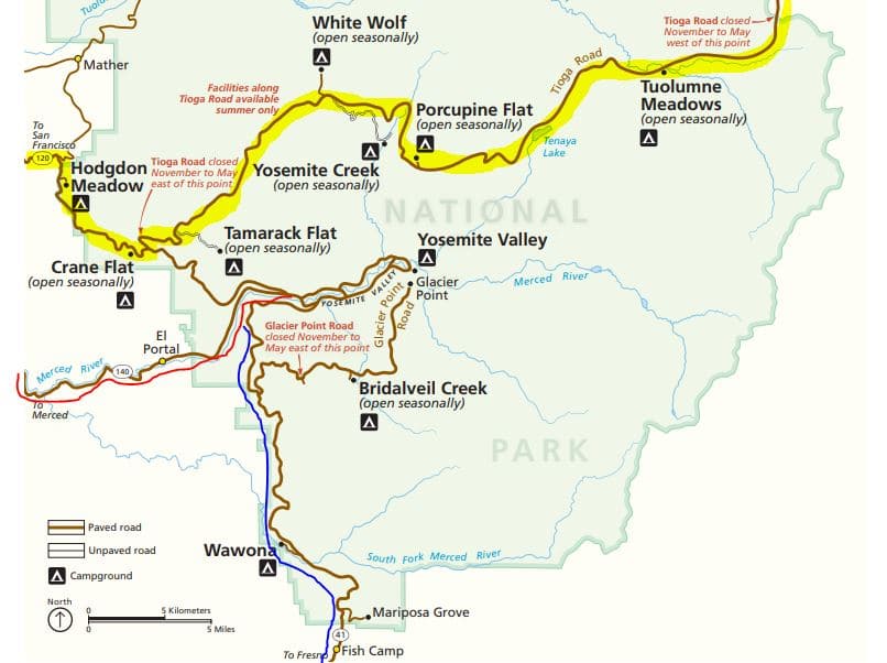
Yosemite National Park has four entrances – South (highway 41, for those arriving form Los Angles, highway 1, or Monterey), West (highway 140, for those arriving from San Francisco), North (highway 120, for those arriving from San Francisco, a similar drive to highway 140), and East (highway 120, open only from May-June until October-November, for those arriving from South Lake Tahoe or Las Vegas).
For how long should I visit Yosemite National Park?
The recommended visit length depends on the season (because roads and trails might be open or closed), and your trip’s overall course (from where are you arriving and to where are you continuing). The park has three main sectors, and each one is worthy of at least a full day:
- Yosemite Valley
- the Tioga Pass area north of the valley
- the park’s south (Glacier Point area and Mariposa Grove)
As such, in the seasons when all the park’s roads are open, you should arrive for at least three days, and when some of the roads are closed you can arrive for a full day or two, mostly centred in the valley. In your visit you should include hikes, through which you can fully witness the park’s magnificence and catch some distance from the crowds. Some especially recommended hiking trails are: in Yosemite Valley – The trail to Vernal and Nevada Falls and Tenaya Lake Trail) an extension of the trail to Mirror Lake); in the park’s south – THe trails to Sentinel Dome and Taft Point; in the park’s north (Tioga Pass area) – the trail to Lambert’s Dome.
A map of the park’s three main sectors (Yosemite Valley in red, Tioga Pass area in blue, the park’s southern area in black):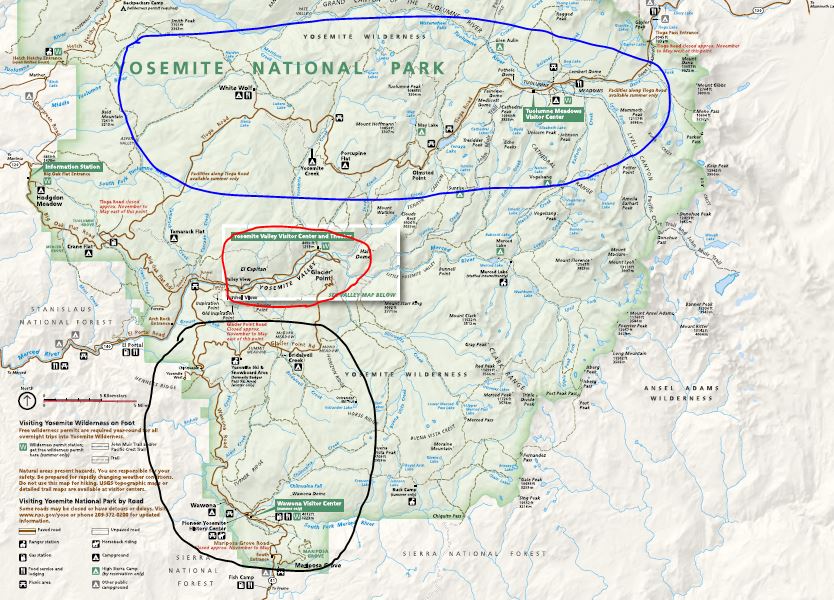
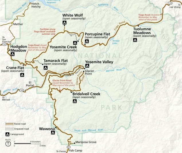
Road Opening schedule and road passability
The roads leading to the park from the west (highway 120), the southwest (state route 140), and from the south (state route 41) are open year-round (if arriving in the park during winter it is better to take state route 140 than highway 120 as it runs through lower elevations). Route 140 can sometimes close due to mudslides, you should check to see that it is open prior to your trip. The Yosemite Valley Road is also open year-round. Tioga Pass Road (highway 120, an amazing drive which reaches almost 10,000 ft of elevation and crosses the Sierra Nevada Mountains)), which traverses the park’s north and leads to Yosemite Valley from the east is closed during winter. It closes when snow starts to pile (usually October-November) and reopens in the spring (April-June). The road can also periodically close during wildfires. Glacier Pint Road, leading to one of the park’s most beautiful viewpoints is closed during winter. It usually closes in November-December and reopens in April-June. RVs of over 30 feet are not allowed in the last section of Glacier Point Road. The road to Mariposa Grove is usually open year-round but can be closed during snowstorms. The road is not passable for RVs. In the winter snow chains are usually required to be carried in the trunk of your vehicle, depending on weather conditions. You might not be permitted in the park without them (a 4-wheel drive might not be required to carry them).
Take Notice! Yosemite’s roads frequently close in the summer due to wildfires. Read more here.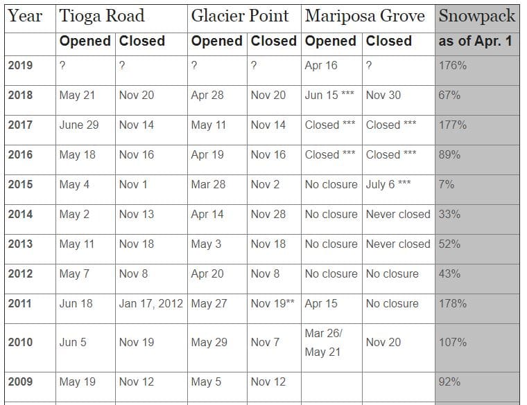
Public Transportation in the park:
In order to reduce traffic in Yosemite Valley, the Parks Service operates two free shuttle lines, which we recommend using – although you can also manage without them, as most of the valley is accessible by private vehicle (except the eastern part – see the dotted green line on the map). Take notice as it might be challenging to find parking in the valley. The Valleywide shuttle line (green on the map) is active only in the summer and takes passengers from the valley visitor center to the valley’s west and El Capitan (this line also goes to Bridalveil Fall). The East Valley shuttle (green on the map) operates year-round and takes passengers from the valley’s visitor center to the valley’s east. A shuttle to Mariposa Grove leaves from the park’s south, near the grove itself. Click here for more shuttle lines and information. 
Recommended hiking trails in the park:
Trails in the Yosemite Valley
Bridalveil Fall: A short hike which leads to the base of the 620 ft high Bridalveil Fall. This is the first waterfall you see when driving the park’s one-way permitter road. Peak water flow is during the spring months, especially May. The end of summer and autumn see a significantly weaker flow.
Lower Yosemite Fall: An easy loop trail leading to the 330 ft high lower Yosemite Fall, from which you can see the middle (670 ft) and upper (1,430 ft) falls. The waterfall is gushing during spring and early summer. At summer’s end the fall is occasionally dry. The trail starts from station 6 of the Valleywide Shuttle. You can start the trail from the valley’s visitor center, which has a parking lot, and walk alongside the bike path that goes to the trailhead.
Mirror Lake: A short trail that goes to Mirror Lake- one of the valley’s most famous trails. When the lake’s waters are still, you can see the reflection of the surrounding cliffs, including Half Dome Peak. The lake dries out in summer and turns into a meadow, making the trail most recommended in winter and spring. The trail is located in the valley’s northeast part and starts at station 17 of the Valleywide Shuttle. This is a popular and crowded trail, so we recommend hiking it in the early morning or late afternoon hours. When arriving to the lake you can extend your hike by walking alongside the lake’s northern shore, and then alongside the northern bank of Tenaya Creek which flows to the lake (most of the way is in the forest and not right by the creek, but there are several access points to the water and swimming holes for when the current isn’t too strong). Continue by crossing the creek by bridge and walking back to the trailhead alongside the creek’s southern bank, beneath the rockfall behind Half Dome Peak.
Vernal and Nevada Falls: A trail located in the south-eastern part of the valley, leading to the base or the top of the 330 ft high Vernal Falls. Along the route there is a great view of the Yosemite Valley. The trail to the base of the waterfall winds along the southern bank of the Merced River, and includes a moderate and not difficult ascent, and a crossing of the river on a bridge from which there is a view of the base of the waterfall. From here you can return to the trailhead or continue to the waterfall’s top on the Mist Trail and continue from there to Nevada Falls (in this case you can return via the John Muir trail).
Upper Yosemite Fall: One of the first hiking trails in the United States, the trail leads to the top of Yosemite Falls which, at 2,425 feet above its base, is the highest waterfall in North America. The views of the valley and the waterfall as seen from the hike are spectacular, especially when water flow is at its peak. The climb is strenuous but undoubtedly rewarding.
Trails in the Glacier Point Area
Sentinel Dome: A trail leading to the top of Sentinel Dome, from which there is a spectacular panoramic view of the park and of Yosemite Valley. This is a beautiful route that should not be missed. The view is great and the ascent to the top of the granite dome is unique. The trail starts in a parking lot next to Glacier Point Road (south of the valley).
Taft Point: A trail that leads through a grove and a meadow to the edge of a towering cliff, from which you can witness a spectacular view of Yosemite Valley, El Capitan Cliff, and Yosemite Falls. While hiking to the cliff’s edge, you pass massive cracks granite stone. The trail starts in the same point as Sentinel Dome Trail, and you can combine the two into one long hike.
Trails alongside Tioga Pass Road:
Dog Lake – A trail that climbs to a lake surrounded by trees and mountains at a height of 9,200 feet above sea level. The trail starts at the Lembert Dome Parking lot located west of Tuolumne Lodge, near the entrance to Tuolumne Campground.
Lembert Dome – A trail leading to a breath-taking view of the Tuolumne River and its surrounding mountains from the granite Lembert Dome which rises to a height of 9,00 feet above sea level. The trail starts at the Dog Lake Parking lot, the first part of the trail is an ascent from the parking lot to highway 120. You can reach Lembert Dome by hiking from the Lembert Dome parking lot located west of the turn to Tuolumne Lodge, opposite the turn to Tuolumne Campground, however the walk from that point is longer.
Lyell Canyon: Part of the 211-mile-long John Muir Trail, constructed in memory of the 19th century conservationist. The JMT crosses the Sierra Nevada Mountains, from Yosemite in the north to Mount Whitney in the south. The Lyle Canyon section, which winds along a tributary of the Tuolumne River, is a very easy trail, and hiking it will result in an almost certain meeting with moose and other animals. While eight miles long, there is no need to walk the entire length, even hiking a mile or two is worth the effort. The trail starts in the same parking lot as the Lambert Dome trail, on the opposite side of the road. Parts of the trail may be muddy after rain. Be sure to carry anti-mosquito spray with you.
Lodging in Yosemite National Park:
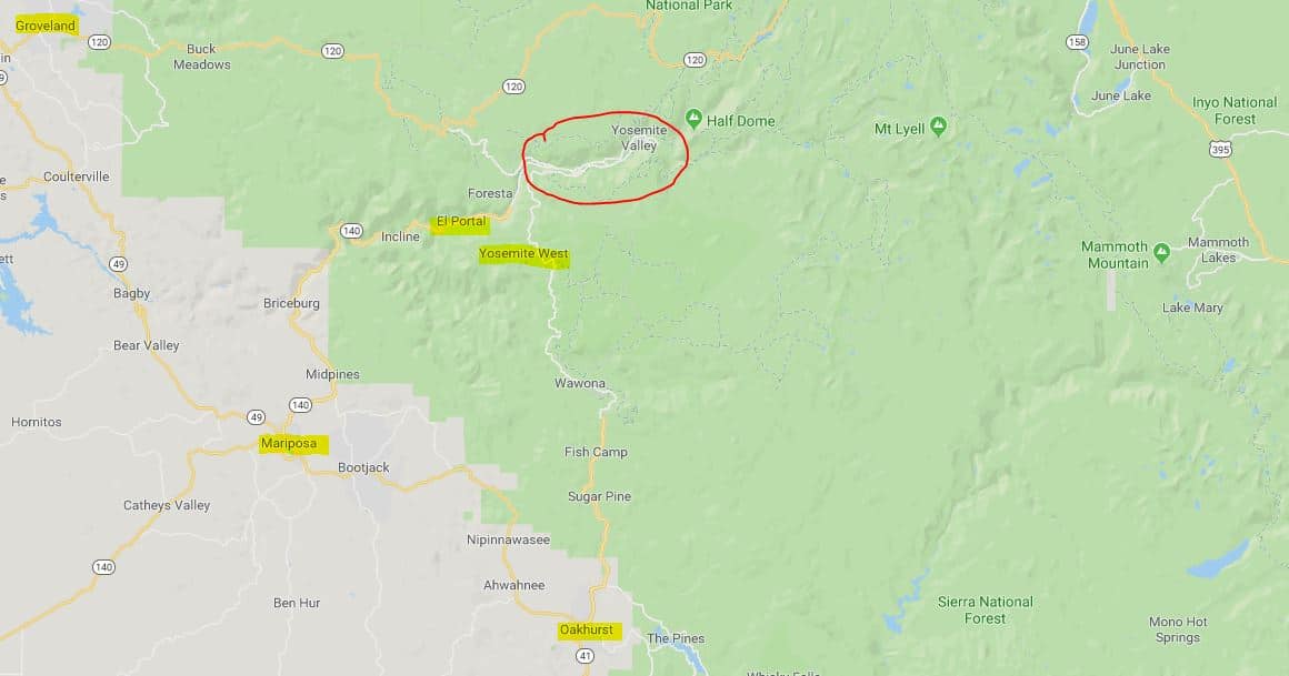
Visitors of the park are recommended to stay in the valley itself (in one of the park’s hotels) or in its vicinity. Recommended places to stay near the valley are: hotels along highway 120 west of the park; hotels in the small community of El Portal, very close to the park’s southwestern entrance (route 140); Or in the Yosemite West area, along Highway 41, not far from the valley (the place offers wooden cabins for rent). It is not advisable to stay in the towns of Mariposa (southwest of the reserve, near Highway 140), Groveland (northwest of the reserve, near Highway 120) and Oakhurst (south of the reserve near to Highway 41), unless staying for the night before entering the park or the night of leaving it. The drive from the valley to these towns is long and winding (especially the road from the valley to Mariposa). Be sure to book accommodation ahead of time, especially if you intend to spend a night in the valley itself (in the park’s hotels).
For hotel recommendations near Yosemite Valley click here.
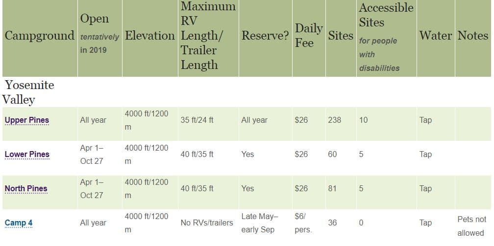
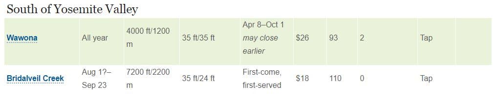
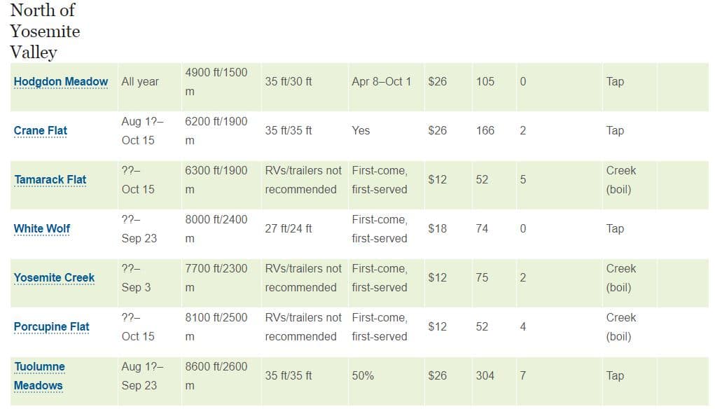
Camping in Yosemite National Park:
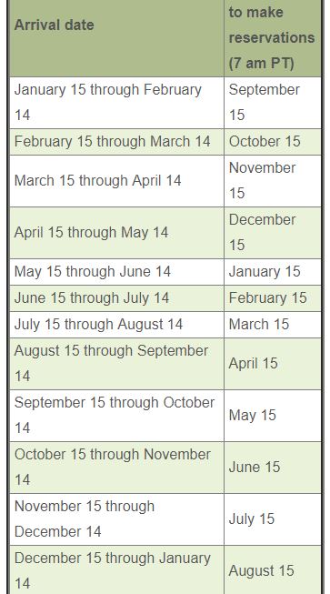
Yosemite’s campgrounds are notorious for the great difficulty of finding vacant campsites. Reservations must be made in advance. The booking window usually opens in one-month increments, five months in advance, on the 15th of each month. (for example, the booking window for March 15th to April 14th opens on November 15th), at 7:00 a.m. West Coast Time. Most sites are usually taken after only a few minutes. You should inquire in advance exactly when your reservation window opens (if, for example, you try to make a reservation six months in advance, you will receive a message on the website telling you on which day you should return to make the reservation). You should also open an account on the reservation site and log in a few minutes before the reservation window starts. If you do not find a place in one of the park’s campgrounds, you can reserve a place in one of the park’s adjacent campgrounds , although they to require you to reserve a place well in advance. (For example Summerdale Campground south of the park ,Indian Flat campground west of the park near route 140, and Dimond O and Yosemite Lakes RV Resort campgrounds west of the park near highway 120).
Click here for more information regarding the park’s campgrounds.
Location of the park’s campgrounds:
For a map of Yosemite National Park click here.
For other national parks in California click here.
For an article ranking all 50 national parks in the lower 48 by beauty click here.
For a free USNPS app of Yosemite click here.