With an Abundance of natural phenomenoms and national parks, the Western United States is a nature lover’s paradise, and there is no better way to witness the magnificent landscape then by foot. The following list features what are, in our opinion, the beat hiking trails in the western USA, including trails in Washington, Utah, Arizona, California and Oregon.
Skyline Trail – Mt Rainier National Park, Washington
This marvelous, extremely scenic hike is one of the most rewarding in the state of Washington and on of the best hikes in the Pacific Northwest. Skyline Trail is located north of Paradise in Mount Rainier National Park and leads to stunning scenery of glaciers, waterfalls and colorful meadows above the tree line. From Panorama Point, the highest viewpoint along the trail, located at elevation 6,800 feet, views of the Cascades Range and of Mt. Adams, Hood and St. Helens, are breathtaking. Along the trail Marmots and Deer can be observed regularly
The length of Skyline Trail is an eight miles loop trail (elevation gain 1,400 feet, moderate difficulty). It is recommended to hike clockwise and to allow 4-6 hours. Hiking the loop clockwise, the trail climbs two miles aside the Nisqually Glacier to Panorama Point and then descends into the Paradise Valley. From the valley the trail climbs to Myrtle Falls and finally returns back to Paradise. For a shorter version of this loop take the Golden Gate Trail back to Paradise
The Skyline Trail trailhead is located near the Jackson Visitor Center in Paradise, south of Mt. Rainier’s summit on State Road 706 (16 miles east of Longmire). Skyline Trail is a great hike for kids although it may be too difficult for young children. The trail is usually snow covered until late June or early July and then again from October. It is advised to check with the visitor center for current conditions. Skyline Trail is relatively crowded on sunny summer days so start early in order to avoid the crowds
 Skyline Trail is of the moderate best hikes in the Pacific Northweat
Hoh River Rainforest Trail – Olympic National Park, Washington
Hoh River Rainforest is located near the Pacific Coast on the western side of the Olympic National Park. This region enjoys relatively moderate temperatures and remarkable amounts of precipitation – up to 12 feet per year, making it the wettest spot in the continental USA. Due to these conditions, temperate dense evergreen rainforests flourish along the Hoh River Valley
The Hoh River Valley Rainforest is probably the most magnificent rainforest within the State of Washington. Trees in this forest – mainly Douglas Fir, Sitka Spruce, Western Red Cedar and Western Hemlock, tower 200 feet and block the sunlight. The lush ground is covered by ferns and moss that compete for space and cling to trees. Fallen trees (also known as nurse logs), provide extra room for plants to grow and eventually create a forest organized into columns and rows. A herd of Roosevelt Elk can be observed in this area regularly. During Autumn Salmon may be seen swimming upstream
Various hikes are possible along the Hoh River Trail. Backpackers can hike through this valley up to the edge Blue Glacier on Mt. Olympus, a total distance of 38 miles (in and out). Elevation gain of this strenuous awarding hike is 3,700 feet, allow 2-3 days. Others may walk only few miles in and out along the lower portion of the Hoh River, and nevertheless find this hike highly rewarding. This trail is great for kids who will adore it’s jungle like setting
The turnoff to the Hoh River Valley Road is located 13 miles south of Forks on US Highway 101. From this intersection, it is another 18 miles to the Hoh visitor Center and the trailhead. Carry a raincoat and come prepared to get wet. The trail along the lower portion of the Hoh River is accessible most of the year
Hurricane Hill – Olympic National Park, Washington
A wonderful, easy, extremely scenic trail, at the heart of the Olympic National Park in the state of Washington. Views from this trail are incredible. Not many trails reach such panoramic, 360 degrees scenery, in so little effort. On a clear day it is possible to see from this trail the Straits of Juan de Fuca, Vancouver Island, Jan Juan Islands and even Mount Baker, one of the volcanoes rising from the Cascade Range. During summer, fields of flowers cover the Hurricane Hill meadow with a carpet of blossom. Dear and Marmots can be observed along this trail regularly
Hurricane Hill trail begins at the end of the winding Hurricane Hill Road near the Hurricane Hill Visitor Center. This is a 3.2 mile (round trip) paved trail that gains 700 feet along the way. Hurricane Hill trial is highly recommended for families with small children (it is even possible to push a stroller along this trail), yet it is extremely popular so be prepared for crowds or plan to start hiking early
To reach the trailhead take the Hurricane Ridge Road (closed in winter) from Port Angeles, pass the Olympic Park Visitor Center and enter the park. Continue uphill for another 18 miles past the Hurricane Ridge Visitor Center and park your car at the end of the road
Dungeness Spit – Dungeness National Wildlife Refugee, Washington
The Dungeness Spit is a scenic easy hike located along on the Northern Shores of the Olympic Peninsula in the State of Washington. This is a wonderful hike for beachcombers, for families with kids and for nature lovers. Waterfowl may be observed frequently along this route. Seals and the spout of whales may be occasionally seen in the water
The Dungeness Spit, located in the Dungeness National Wildlife Refugee, is a narrow natural stretch of sand that extends into the Straits of Juan de Fuca, separating between the Olympic Peninsula and Vancouver Island. Along the spit, one of the largest of its kind in the world, thousands of logs that were thrown on the beach by the ocean’s powerful waves, create a great outdoor playground and maze for kids
The Dungeness lighthouse is located at the end of this spit, 5 miles from the trailhead. The distance between the trailhead and the beach is half a mile (one way). From there it is possible to walk to the lighthouse and back a distance of another 4.5 miles one way. Since the beach is pretty at the start of this trail as it is at the end it is not necessary to hike the whole distance. To reach the trailhead turn north on Kitchen-Dick Road, off Hwy 101, west of Sequim and continue 3 miles to Dungeness Recreation Area
Ape Cave – Mount St Helens National Volcanic Monument, Washington
Ape Cave is one of the longest lava flow tubes in the Unites States. This cave, which is 13,000 feet long, is located on the southern slopes on Mount Saint Helens, in the State of Washington. It was created about 2,000 years ago, when the outer portion of a basalt lava flow formed a hardened crust. When the inner part of this flow drained, an open tunnel was created. Ape Cave is named after a group of local scouts called Brush Apes that sponsored the first expedition of this cave
While the upper section of this cave is rough and not recommended for small kids, hiking the lower section is easy and great for families with kids. The length of this trail is 1.5 miles round trip, elevation gain 100 feet. The length of the more strenuous trail along the upper section is 3 miles round trip. Both hikes are highly recommended and offer a unique experience, especially for those traveling for kids. Don’t forget to bring plenty of flashlights along and be sure to turn them off for a few minutes while underground in order to experience total darkness
To reach the Ape Cave from I-5, take exit 21 and head east toward the small town of Cougar. At 7 miles past Cougar turn left to Forest Road 83, drive 2 miles to Forest Road 8303, turn left again and drive another mile to the cave. If you have spare time don’t miss another great hike for kids – Trail of two Forests, located nearby
Multnomah Falls Hiking Trail – Columbia River, Oregon
620 feet Multnomah Falls, plummeting from vertical cliffs to the Columbia River Gorge are breathtaking. The trail to these falls, between dense temperate evergreen rainforests is one of the most popular in the State of Oregon, attracting nearly 2 million visitors per year
The length of the trail to Multnomah Falls is 2.4 miles (in and out). Elevation gain is rather significant (600 feet), but since the path is well graded, this trail is relatively easy. Those who wish to walk a shorter distance can observe the falls from the bridge located a short hiking distance from the trailhead. Fit individuals or families who wish to lengthen this trail and beat the crowds can hike the more strenuous Wahkeena-Multnomah Falls loop. This 5.5 mile beautiful trail winds through dense rainforests along pure streams and half a dozen waterfalls, and reaches great viewpoints of both Multnomah and 240 feet Wahkeena Falls (loop trail, hike clockwise, elevation gain 1,500 feet)
Multnomah Falls are located off Interstate Highway 84, 30 miles east of Portland, Oregon (use Exit 35 if traveling East and Exit 28 if traveling West). A Visitor Center, located near the trailhead, is a great place to ask for information and obtain maps. Since Multnomah Falls are extremely crowded on sunny summer days, start early in order to avoid the crowds. Weather in this area may be wet and damp, so carrying a raincoat in your backpack is a good idea
Lassen Peak Trail – Lassen Volcanic National Park, California
Lassen Peak Trail, located in Lassen Volcanic Park, in northern California is one of most rewarding in the state when it comes to scenery. This trail climbs Mount Lassen, the southernmost peak of the Cascades Mountain Range, an active, yet dormant, volcano that had last erupted in 1915. Mount Lassen is the only volcano in the Cascades besides Mount St. Helens that had erupted during the 20th century
Despite this being a strenuous hike, it is no doubt worth the effort. From the summit of Mount Lassen, panoramic views of Mount Shasta to the north and of forests, lakes and small volcanic cones to the east and west are superb, and vistas on cloudless days, are incomparable. Rotten egg smell of hydrogen sulfide near the summit is common, reminding hikers that Mount Lassen is still an active volcano
The 5 miles hike (in and out) to Lassen Peak is rather difficult ascending steep rocky switchbacks, from the trailhead at 8,500 feet, to the mountain’s summit at 10,457 feet. It is highly advised to start this trail early in the morning since during summer strong winds usually increase in the afternoon. Do not hike this trail if there is any chance of lightning. The trail is usually snow covered until late June or early July and then again from October. Trail maps and additional information is available at the visitor center. The trailhead is located off Lassen Park Highway, 7 miles north of the park’s southern entrance
Sentinel Dome – Yosemite National Park, California
If you have time to hike only one short trail in Yosemite National Park, Sentinel Dome Trail is no doubt the one to choose. This trail, which climbs one of Yosemite’s typical granite domes, offers breathtaking 360 degrees views of the Yosemite Valley and of the surrounding Sierra Nevada mountain range in the state of California
Sentinel Dome is a moderate hike, 2.2 mile long (in and out), elevation gain 400 feet. It is a one-mile relatively flat hike to the base of the dome. A short climb up the smooth granite leads to the dome’s summit. From the summit, located at an altitude of about 8,100 feet, hundreds of feet higher that Glacier Point, views of Half Dome, El Capitan and Yosemite Falls are absolutely stunning
The Sentinel Dome trailhead is located off Glacier Point Road in Yosemite National Park, 9 miles from Hwy 41. This is also the trailhead for the magnificent Taft Point trail. Best time to hike Sentinel Dome is late afternoon since viewing the sunset from the dome’s summit is particularly scenic. This hike is great for families with kids that will surely enjoy the scramble up the granite. Do not attempt to climb this dome during thunderstorms. Glacier Point Road is closed in winter. This trail is usually snow free from late June to October
Vernal & Nevada Falls – Yosemite National Park, California
The strenuous hike to the magnificent Vernal and Nevada Falls, plummeting from vertical granite cliffs to the heart of Yosemite Valley, is one of the most rewarding in Yosemite National Park. The hike combines great views of the Yosemite Valley and of the beautiful pure Merced River
This 7 miles long loop hike (elevation gain 1,800 feet) starts at Happy Isles (shuttle stop 16) at the eastern corner of the Yosemite Valley and parallels the Merced River while ascending to Vernal Falls. From the footbridge at the base of Vernal Falls, the trail climbs up a steep stairway to top of the fall and to Emerald pool. This portion of the trail, called Mist Trail, may be slippery and wet, and is closed in winter. The trail eventually leads to the brink of the 590 foot tall Nevada Fall, a total elevation gain of 2,000 feet. On the way back it is recommended to join the John Muir trail that descends to the valley floor
It is possible to shorten this hike by turning around after reaching the footbridge at the base of Vernal Falls and hiking back to Happy Isles. This option, that is 1.6 miles long in and out (400 feet elevation gain), is great for families with kids and includes wonderful views of the valley and of the unique cliffs that surround it
 The climb to the top of the Vernal Fall is crowded but rewarding. This is one of the Yosemite’s Valley best hikes
Moro Rock – Seqouia National Park, California
Moro Rock is a huge impressive granite dome located in the mighty Sierra Nevada Mountain Range in Sequoia National Park in Southern California. A series of 400 stairs, carved 80 years ago in the rock, leads hikers and travelers to this magnificent 6,700 feet top of the world viewpoint. This steep, short, 0.3 mile (one way) trail gains an elevation of 300 feet. The climb to top of Moro Rock is quite strenuous, yet rewarding. Scenery of the San Joaquin Valley and of the snowcapped peaks of the Great Western Divide from this dome is absolutely breathtaking.
The best time to climb Moro Rock is early morning or late afternoon, when visibility is at its best. This hike is indeed great for families with kids although some portions include steep drop-offs, so be cautious. Do not hike if there is ice or snow on the stairs and absolutely do not go up during thunderstorms
The trailhead leading to Moro Rock is located off Crescent Meadow Road in the Giant Forest area of Sequoia National Park, 2 miles from the Generals Highway. This trail is very popular and may be extremely crowded during summer holidays and weekends. Arrive early if you wish to avoid the crowds
Hidden Valley Trail – Joshua Tree National Park, California
Considering the fact Hidden Valley Trail is only one mile long, and that it is a very easy, loop trial, the scenery this hike offers is outstanding. There are only numerous trails in the National Parks system that provide so much beauty for such a little effort. Hidden Valley Trail is a pleasant stroll, wonderful for families with small children
Hidden Valley is a rock-enclosed valley located at the heart of Joshua Tree National Park in Southern California. It was formed by bare granite rocks broken up to loose boulders and shaped by erosion and tectonic forces. The trail within this valley winds through desert terrain between a maze of red, orange and brown colored rocks. Along the trail, many rock climbers can be observed, clinging to vertical cliffs that attract climbers from all around the world
The trail starts at the Hidden Valley Picnic Area in Joshua Tree National Park. This trail is great for hiking year-round. During hot summer days is advised to hike in the morning or late afternoon. Besides cooler weather, these times of day offer splendid photo opportunities. A wonderful campground – Hidden Valley Campground, located in proximity to this trail is a great place to spend the night in. While traveling in the park do not miss a visit to the Keys Viewpoint, preferably before sunset. On clear days the view from this vista extends beyond Salton Sea to Northern Mexico
Calf Creek Falls – Grand Staircase Escalante, Utah
Lower Calf Creek Falls Trail is a beautiful hike, leading to a breathtaking oasis – a picturesque waterfall plummeting 125 feet, from a steep cliff in the middle of an arid desert. The trail is located in the vast wilderness of one of the largest National Monument in the continental USA – Grand Staircase Escalante, named after a series of stairs in which the Colorado Plateau descends towards the south, into the Grand Canyon
Calf Creek Falls Trail starts at the Calf Creek Recreation Area, 15 miles east of the small town Escalante, off hwy 12 (between milestone 75 and 76) in the state of Utah. The length of this trail is 5.5 miles in and out. Although elevation gain is minimal, this trail is not easy – walking on the soft sandy riverbed may be strenuous. The trail ends beneath the waterfall, where a wonderful natural pool provides a delightful opportunity to cool down. Few Indian petroglyph sites and be viewed along this trail
If you plan the hike this trail during summer, be sure to carry plenty of water and to start walking early in the morning since large portions of this trail (mainly the first part) are exposed, and provide minimal shade. In case there is a chance for rain do not hike this trail since flash floods are common in this area and are extremely dangerous
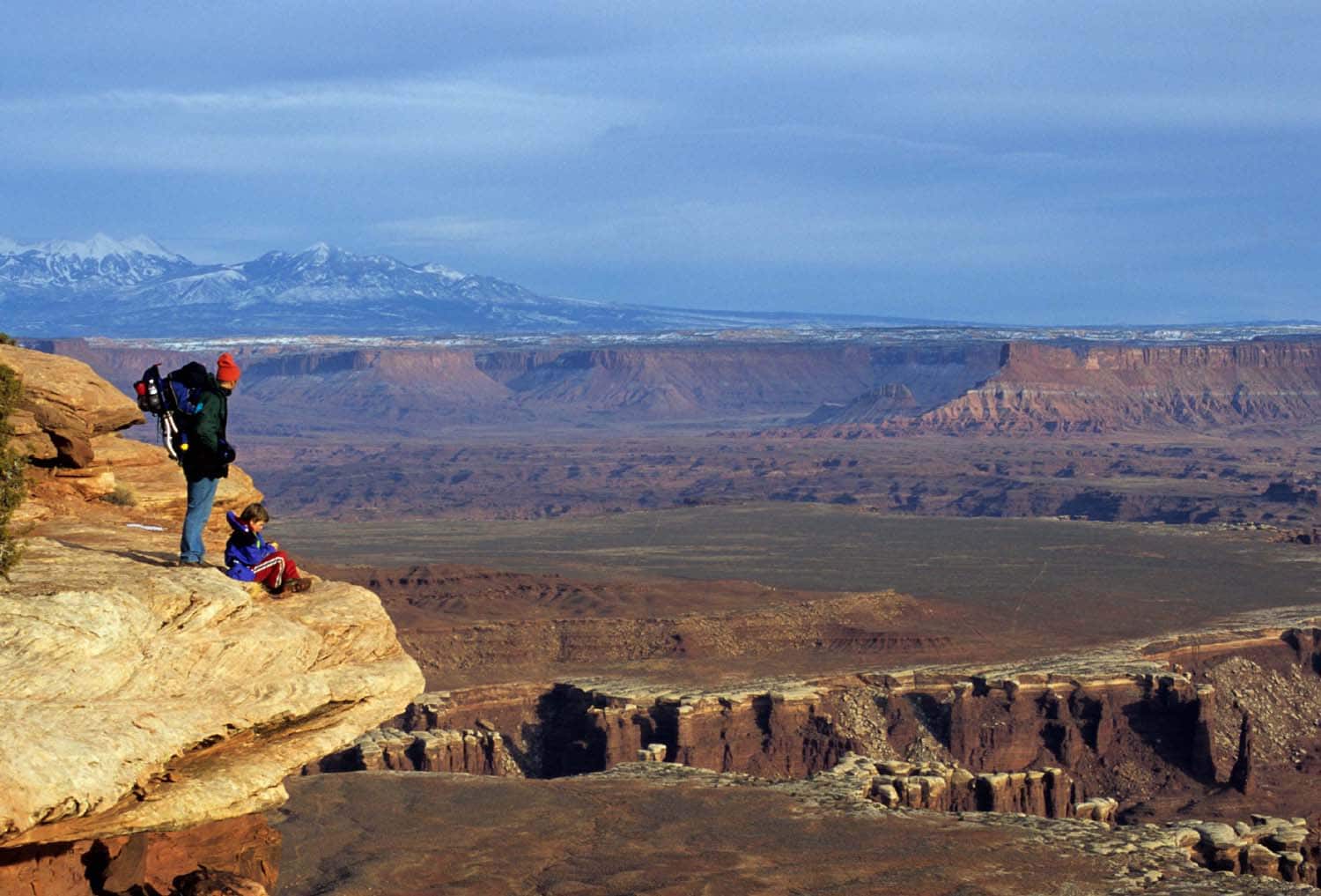
Grand View Point – Canyonlands National Park, Utah
Grand View Point Trail is not doubt one of the most rewarding, breathtaking hikes in the world, and one of the short best hikes in the USA! This relatively flat, easy, 2 miles (in and out) trail, located in the Islands in the Sky district of Canyonlands National Park offers pure scenic beauty of southern Utah’s vast arid wilderness. This trail leads to the very end of the Islands in the Sky Mesa, from which panoramic views are outstanding. This viewpoint overlooks the confluence of the Green and Colorado Rivers and the Maze district of Canyonlands National Park
Grand View Point trail parallels huge vertical cliffs, and all the way in and out provides a bird eye view of the horseshoe bends of the mighty, impressive Colorado River. This is great hike for all people of all ages. If you are planning on taking small kids on this hike be cautious since the drop-offs alongside this trail are extremely steep
To reach the Grand View Point trailhead drive from Moab north on US 191 for 10 miles, turn left on SR 313 and drive 22 miles to the park’s Visitor Center. Continue past the Visitor Center and after 7 miles turn left and drive another 6 miles to the trailhead. Best time to hike this trail is during the morning and afternoon when the reddish desert hue is at it’s best
 Grand View Point Trail is one of the short best hikes in the USA
Slickrock – Canyonlands National Park, Utah
Slickrock Trail is one of the short best hikes in the Needles District of Canyonlands National Park. This 2.4 miles hike is extremely scenic and offers colorful desert views of Buttes, Mazes and Needles. The numerous vistas along the trail provide magnificent scenery of Utah’s infinite wilderness and of the southeastern corner of Canyonlands National Park. At some points along the route impressive deep canyons surround this trail from all directions
Slickrock Trail is a great hike for families with kids since it is rather short and quite easy, with only 100 feet elevation gain. Since this trail lacks shade be sure to carry plenty of water. This trail is marked mainly with cairns (small rock piles) with some signs located at trail intersections. Part of this trail is an in and out hike and part is a loop trail. It is recommended to hike the loop portion of the trail counterclockwise. Big Horn Sheep may be occasionally observed along this trail
The Slickrock trailhead is located very close to the end of the Big Springs Overlook Road in The Needles District of Canyonlands National Park, 7 miles from the Visitor Center. Best time to hike this Slickrock Trail is during the morning and afternoon when the reddish desert hue is at it’s best
 Slickrock is one of the short best hikes in Canyonlands National Park
Delicate Arch Hike – Arches National Park, Utah
From all the 2,000 sandstone arches in Arches National Park, Delicate Arch is without doubt the most famous. This arch, which rises from a bare sandstone slope facing marvelous views, has become a symbol of Southern Utah and has even been depicted on the license plates of this scenic state
The opening of Delicate Arch is huge – 33 feet in width and 45 feet in height. It was formed by weathering and erosion in the Entrada Sandstone, and due to it’s dramatic location and fragile nature has become so famous. A shot of Delicate Arch with the background of snowcapped 13,000 feet La Sal Mountains, is one of those every visitor to the park must have. This hike should definitely be first in priority for those visiting Arches National Park
The Delicate Arch hike, on of the best hikes in the USA, is 3 miles long (in and out). This is a moderate hike with an elevation gain of nearly 500 feet, a perfect place to take the kids to. The first half mile of the trail is mostly level following a gradual descent on slick rock. The trail starts at the Wolf Ranch in Arches National Park. During summer this trail is very hot and exposed and carrying plenty of water is required. During winter this trail may be slippery and icy. Get updated about current conditions in the Visitor Center located at the entrance to the park off Highway 191
Fiery Furnace Hike – Arches National Park, Utah
Fiery Furnace is an exceptional maze of sandstone fins in Arches National Park. An incredible labyrinth of red and orange colorful slick rock in this spectacular National Park, which boasts the highest density of sandstone arches in the world. Some of the walls in Fiery Furnace are more than 200 feet tall limiting sunlight to the sandy wash bottoms. Within this maze there are hidden arches, spires and grottos created by erosion of wind and water
Since it is very easy to become lost and disoriented in this area, visiting Fiery Furnace requires obtaining a special permit (permit is available only for experienced hikers familiar with this area, fee charged) or joining a Ranger guided hike. Three hours guided hikes to Fiery Furnace, which are moderately easy are offered from mid March to October twice a day. These hikes are 2 miles long (loop trail) and require scrambling through narrow cracks and ledges. Elevation gain is minimal – around 150 feet
Since Fiery Furnace hikes are very popular and fill up quickly, it is advised to register in at the Visitor Center in person up to 7 days in advance or online (up to 6 months on advance). Fee is charged for these hikes, kids up to 6 years old are free
The Narrows Hiking Trail – Zion National Park, Utah
The Narrows is one of the most unique hikes in Zion National Park, an extraordinary trial that combines desert beauty with pure flowing water. Imagine yourself during a hot summer day, hiking in cool water in a setting of a red sandstone desert… Hiking the Narrows is an ultimate wilderness experience
The Narrows is actually a gorge of the Virgin River. It is 16 miles long, up to 2,000 feet deep and only 20-30 feet wide. Hiking the Narrows is not easy and should not be underestimated. It involves walking, wading and sometimes swimming in the stream that may be swift, cold and slippery. The route is in the river itself, there is not maintained trail in the Narrows. Since flash flooding is a constant danger, it is essential to obtain an updated weather forecast before embarking on this trip (the Visitor Center is the best place to get information). Hiking the Narrows is safest when the river is low. Hiking in winter requires dry suites
There are few possibilities to hike the Narrows. The easiest is to hike from the bottom and back. This hike starts at the end of the Riverside Walk and does not require a permit. To reach the trailhead, take the shuttle to the Temple of Sinawava. Another option is to hike from top to bottom the entire length of the Narrows. This 16 miles strenuous hike takes about 12 hours. The trailhead is located next to the Chamberlain’s Ranch, a 1.5 hours drive from the Zion Valley. This hike requires a permit available at the visitor center. The number of permits is restricted. A commercial shuttle is available to Chamberlain’s Ranch (for more information contact the visitor center). It is also possible to stay overnight in one of the 12 campsites along the route and hike this trail more leisurely
Angels Landing Hike Trail – Zion National Park, Utah
If you are in relatively good shape and have time to hike only one trail in beautiful Zion National Park, the thrilling Angeles Landing is definitely the one to choose. This highly recommended hike, one of Zions, best hikes, ascends via steep switchbacks, constructed on a red rock cliff above the Virgin River, to one of the most magnificent views of the Zion Valley. Angels Landing is a relatively strenuous hike, but since most of it is well graded, it is possible to hike this trail with children, who will surely appreciate the spectacular beauty along the way and from the 360 degrees viewpoint
The length of the Angels Landing Trail is 5 miles (in and out) and elevation gain is 1,500 feet. This trail starts at the Grotto Picnic Area in the Zion Valley, crosses the Virgin River and then starts ascending on the valley’s cliff. During this quite difficult portion of the hike, that is 2 nearly miles long, the trail is mostly exposed and therefore an early start in hot summer days is advised. At the end of this significant climb, the trail reaches the shaded narrow Refrigerator Canyon, a gap between Angels Landing and Cathedral Mountain and a great place for breakfast or lunch. After a short hike through this canyon, the trail ascends steeply again for about half a mile, across a sandstone ridge, until it reaches the Angels Landing viewpoint
Angels Landing Trail is not suitable for those fearful of heights. Trail may be snow covered and icy during wintertime. Check current conditions in the Visitor Center. During summer months carry plenty of water
Rim Trail – Grand Canyon National Park, Arizona
Travelers to Grand Canyon often face the same problem – the scenery is indeed breathtaking, but the hiking opportunities, for those who do not wish to embark on a strenuous descent and ascent, are limited. The Rim Trail is the best solution for this problem and actually quite a recommended trail that can fill your day with great scenery of one of the most magnificent places in the world
The Rim Trail is located on along the south rim of the Grand Canyon in Grand Canyon National Park in the state of Arizona. The length of this trail, which stretches from Pipe Creek Vista to Hermits Rest, is 12 miles one way. Most of the trail is flat and rather easy and some sections are paved. Since the park offers free shuttle service, you may hike this trail one-way and reach your vehicle by using the shuttle (please note – private cars are not allowed in the Hermits Rest Route leading to Hermits Rest)
If you want to avoid the crowds, hike the 4 miles section of this trail between Maricopa Point and Monument Creek Vista, which is not paved, and includes mild descents and ascents. Hiking the paved portion of the Rim Trail during full moon nights is a great experience, as is watching the sunrise and sunset from one of the numerous viewpoints set along this trail
Havasu Canyon Hiking Trail – Grand Canyon, Arizona
Words alone cannot describe well enough the beauty of the Havasu Canyon – a place where turquoise water flow between amazing red desert canyon cliffs and a series of waterfalls cascade into magnificent travertine pools. Havasu Canyon is a true gem off the beaten path. An oasis along the Havasu River one of the tributaries of the mighty Colorado, that has carved the Grand Canyon in Arizona
The hike to the Havasu canyon is 10 miles long (one way) and although the way in is relatively easy, going out of the canyon is more difficult since it includes climbing steep switchbacks (elevation gain 2,400 feet). 75 feet Navajo Falls and 100 feet Havasu Falls that plunges into a pool of blue-green water, are located approximatley10 miles from the trailhead and are the first to greet hikers. 200 feet Mooney Falls and the Beaver Falls cascades are located another mile and three miles respectively down river. The confluence of the Havasu River and the Colorado River is located five miles from Beaver Falls. This hike is great for fit families with fit kids and provides a once in a lifetime experience. Allow at least three days (preferably more) – one day in, one day out and one day in the canyon, for this hike
The Havasu Canyon is located in the Indian Havasupai Reservation that manages the lodge at the village of Supai located two miles from the canyon (eight miles from the trailhead), and the campground set along the Havasu River. The number of hikers allowed in the canyon is restricted and camping or lodging reservations are required and must be made well in advance. Luggage may be carried in and out by mules, if reserved. Although there is a small grocery store at the village of Supai, it is recommended to carry in food. Drinking water is available in the campground. Regular Helicopter service is available for those who wish to fly in or out
The trailhead is located at Hualapai Hilltop at the end of Indian Route 18, north of Peach Springs off Highway 66, three hours drive from Flagstaff, Arizona. Best time to visit is spring or fall – winter is cold, summer is monsoon time. It is highly advised to start hiking early to avoid the midday heat during the summer and to carry plenty of water. For more information go to: www.havasupaireservations.com
 The amazing Havasu Falls which are reached after a 10 mile hike